Monday, April 24, 2017

Scouting Sleepy Hollow Marshland

Panorama of the Marshland at the north end of the park. Note stepping stones to get across the stream:
There are vestiges of paths here but the highest ground is along the small creek. Prickler bushes abound :-(
kinda dry but can get mucky
looking back
there's a mini stream crossing here
Haig Ave Field
panorama of the field

Old Bridge Remnants

There must have been a trail around the park at one point!
Ruins of an old bridge -

roots (almost like a mangrove swamp!)
Once back by the pond (on the west side still) I retraced a path...
vestiges of a path
what's left of the bridge on the east side
there are blue ribbons that mark this pseudo trail - it does lead all around the pond

Monday, April 17, 2017

Sleepy Hollow Park - review

An Earth Day Session to improve this park is set for this Sat. I went in after supper and did a quick walk through to understand the potential for building a trail system.

The feeder river is a swampy mess - clearing this may help a bit
Weird Short Construction Road
Proud Residents of the Park!

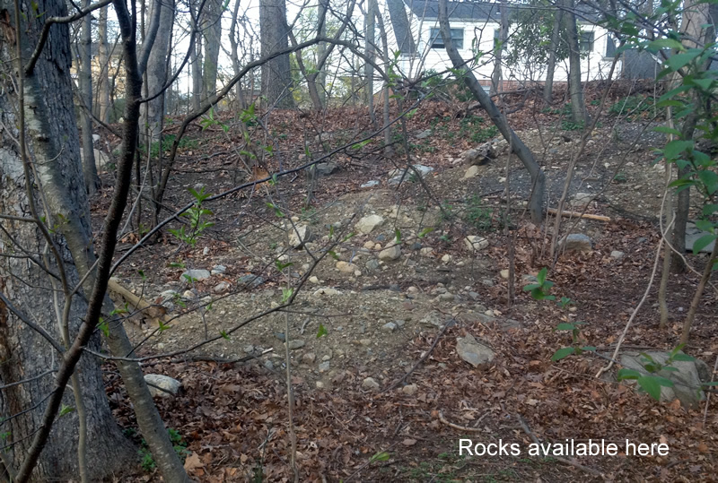
We will need rocks to create walkable crossings for the muddy areas, etc. A couple of spots were located...
 The "Trail"

The trail seemingly continues thru the woods but this section will need a lot of "improvement" as drainage is a big issue...

There are scattered locations to pull logs for corduroy crossings and makeshift "balance beam" crossings.

Connecting with Haig Ave. might be best served by paralleling the stream (folks love to walk next to a stream)

Thoughts...

Lastly, it would seem the goal also would be to build a trail that circles the pond and reconnects with the old bridge crossing.


Saturday, April 15, 2017

Saturday Hemlock Hills GPS Trek

I hiked in from the Lake Windwing lot to check on the GPS and blazing in the southeast section of Hemlock Hills

 Red Trail "West to East"

I trekked on up the hill to where the new FCNEMBA trail work was done the week before, making note of the intersections and landmarks along the way.


looking back...
Dirt Road continues off to the East
Red Trail is a left turn
At the Ski Trail intersection
Heading up the Red Trail
Tight Turn
Super Tight Switchback (Boy Scout built) 
Rocky Climb 
Two Photo Stitch

Quick and Dirty map of the new trails
(RCC-approved - FCNEMBA Built)

After passing the trail work and continuing on the trek further east, here is the intersection that connects with the new (rerouted) trail off to the left that avoids the vernal pool.
I returned to here to hike out on the lower White Trail
Nice slick rock here
I made this intersection the "end of the line" today (after a short trek down the Orange Trail offshoot)

Orange Trail (Offshoot)

This is the side trail that leads out of the park (it's an old road)
xx

White Trail

I turned off on the barely used White Trail (There are numerous trees down and leaf cover over the beginning of this trail). It eventually connected with the Orange Trail at the bottom of the hill.

As mentioned above, here is the intersection with the barely used White Trail
Lower White Trail

Summary

Helpful info acquired for the area trail map (...mainly familiarizing myself with the popular Red Trail)