I hiked in from the
Lake Windwing lot to check on the GPS and blazing in the southeast section of Hemlock Hills
Red Trail "West to East"
I trekked on up the hill to where the new FCNEMBA trail work was done the week before, making note of the intersections and landmarks along the way.
 |
| looking back... |
 |
Dirt Road continues off to the East
Red Trail is a left turn |
 |
| At the Ski Trail intersection |
 |
| Heading up the Red Trail |
 |
| Tight Turn |
 |
| Super Tight Switchback (Boy Scout built) |
 |
| Rocky Climb |
 |
| Two Photo Stitch |
 |
Quick and Dirty map of the new trails
(RCC-approved - FCNEMBA Built) |
After passing the trail work and continuing on the trek further east, here is the intersection that connects with the new (rerouted) trail off to the left that avoids the vernal pool.
 |
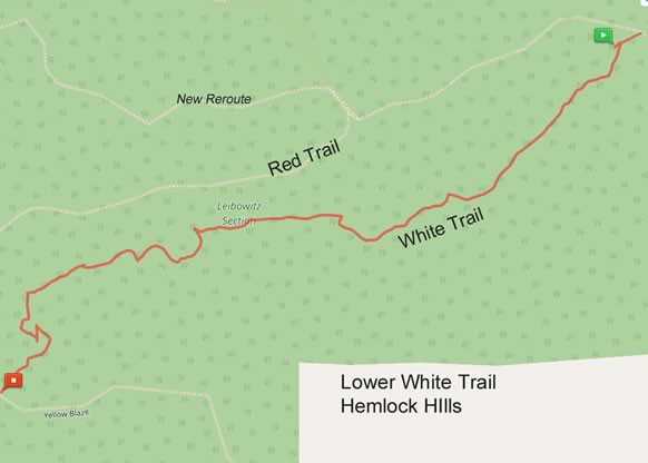
| I returned to here to hike out on the lower White Trail |
 |
| Nice slick rock here |
 |
| I made this intersection the "end of the line" today (after a short trek down the Orange Trail offshoot) |
Orange Trail (Offshoot)
This is the side trail that leads out of the park (it's an old road)
xx
White Trail
I turned off on the barely used White Trail (There are numerous trees down and leaf cover over the beginning of this trail). It eventually connected with the Orange Trail at the bottom of the hill.
|
| As mentioned above, here is the intersection with the barely used White Trail |
 |
| Lower White Trail |
Summary
Helpful info acquired for the area trail map (...mainly familiarizing myself with the popular
Red Trail)


No comments:
Post a Comment