Took a quick hike to the Cotton Hollow Mill and got close up today!

 |
| Yep I got my feet wet.... |


- Short Video -
Looking upstream from the mill, there's remnants of the higher dam barely visible as well...(future trek!)


Took a quick hike to the Cotton Hollow Mill and got close up today!
|
| Yep I got my feet wet.... |
Late afternoon--after a jaunt around my backyard forest trails--I went down to Upper Cotton Hollow for a quick hike. I should have worn my crampons as is what pretty slippery in spots so I didn't go that far. Needless to say, it was still nice in the late afternoon sun...


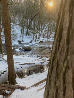


I took my visiting friend Kevin to a couple of favorite spots. It was late afternoon and the weather was cold but things were still looking beautiful!


Hardly much of a trek but nevertheless--being a history buff--these local spots warranted researching and posting. :-) All black & white historical photos below were sourced from the Arcadia Publishing: "Glastonbury" book - courtesy of the Historical Society of Glastonbury (which I am now a proud member)!.
Although South Glastonbury was never near a railroad, it did have a street car line. The Trolley Line was extended from Hubbard Brook to Roaring Brook in 1893.

 |
| Streetcar in front of the post office |

The building to the left is the salesroom of Hopewell Mills

This mill--located where High Street crosses the Roaring Brook--was originally known as the Roaring Brook Paper Manufacturing Company. There was a sawmill and paper mill to make binder's boards for book covers. Later known as the Hollister Grist Mill it was eventually converted it into a grinding mill for processing the feldspar mined in nearby quarries and renamed the Spar Mill.

1880's view of the mill


 |
| the house, visible on the right, is in the historic photo above |

Much has been written about the former Cotton Hollow Mill which I visited even before I moved here! see post >. It was and still is an impressive site! The dams here were 24 and over 50 feet high and the 80-acre site included 19 houses where factory workers lived.


 |
| The large dam was blown up in 1904. |

On Wednesday, I returned to the Cotton Hollow Preserve, hiking in from the entrance off Main Street. The creek was still high from the Tropical Storm Elsa (last Friday) and there was washed up sand everywhere on the way in and along the river.

Once I got the the end of the official trail, the foliage blocked a decent view of the mill ruins at the lower dam remnants- bummer!


I was itching to go further upstream to try and check out any upper dam ruins but despite a crazy climb uphill for a bit - I couldn't find a trail leading across the ravine to get further upstream - double bummer!


I ventured down to Cotton Hollow Preserve in the early evening as I was curious what I would be like after the tropical storm. Yikes - it didn't disappoint!


My good friend Kevin Malone came up to visit and we went on an adventure in Cotton Hollow. My goal was to reach the old 3-story mill ruins. Despite rigorous mountaineering over some very treacherous trails, we were only able to get close enough to barely see it. The last stretch was impassable :-(


 |
| This is the swimming hole... |
 |
| Gorgeous scenery! |

 |
| The climbing was crazy!!! |


 |
| Hard to tell but we are up pretty high... |


Yep - another wonderful adventure checking out the splendors of South Glastonbury - Ooo yeah!!!
