Friday, December 30, 2022

Coop Road - Case Mountain

In keeping with my recent "Abandoned Road Exploration" theme, I road Coop Road at Case Mountain today. The weather was amazing for this time of year - in the 50s and sunny so it was a pleasant ride. My destination was the former bridge...

The purple arrow indicates where I veered off the old road and had to ascend the powerline trail instead.  It looked pretty daunting but I made it without dismounting!

The first stretch until the power lines is pretty straight ahead -- I've ridden it before.

Yikes - -the powerline ascent!
Back on the old road...
I made it the the bridge- yeah!
To the east is what appeared to be remnants of an old dam...
...and another (nicer) trail
On my way back - I snapped a photo of the powerline hills

Thursday, December 29, 2022

Back at Hollister-Whitehouse Preserve

After exploring the old Country Club road,  I headed over to the Hollister-Whitehouse Family Nature Preserve to hike a section I still hadn't visited. It was late in the afternoon and much of the hike is in a deep valley with very little sunshine so the photos are kinda lousy. I can imagine in the sunny summer with the trees lush with foliage,  this stretch would be gorgeous.


Remnants of Country Club Road

Today I continued on my old road sleuthing project and checked out the remnants of Country Club Road. There are now two dead-end paved sections because apparently around 1972, the town decided to abandon the middle section of the road and now its just a washed out mess but interesting nonetheless.

Location
1869 mpap

I walked in from the country club side and headed west...

Its pretty much impassable now - even by mountain bike but its still clearly defined with rocks lining the edges in spots.
Once at the other end of the washed out remnant I turned around
Crude 4-photo panorama...
The sunlight on the way back was nice...
Off to the side was a boulder "garden" - glacial erratics - a vivid reminder of the mighty ice age

I then ventured over to the Hollister-Whitehouse Preserve...

Further Info

Country Club Road (Hollister Road)

Wednesday, December 28, 2022

Old Road Sleuthing

East of Keeney Street there appeared to be vestiges of an old road. Curiosity got the best of me today as I went there to check it out.

Although it dissipates after a short while--it WAS a road...As the photos below indicate, this stretch look manmade (but long abandoned). After surveying the area, methinks it was probably created when the road crews were upgrading Keeney Street and needed fill. 

After the road disappeared into nothingness, I walked a bit along the ridge. This would be great for mountain biking!
On my way back out, I snapped a few more photos.This hollowed out area could have been where fill was dug out for road construction.

Thursday, December 22, 2022

Sleeping Giant

Massive tectonic forces and huge basalt uplifts in li'l ol' Connecticut? You betcha!
"Sleeping Giant, a fault-block ridge that formed 200 million years ago during the Triassic and Jurassic periods, is composed of traprock, also known as basalt, an extrusive volcanic rock. Huge slopes made of fractured basalt scree are visible beneath many of the ledges of Sleeping Giant. The basalt cliffs are the product of several massive lava flows hundreds of feet deep that welled up in faults created by the rifting apart of North America from Eurasia and Africa. These basalt floods of lava happened over a period of 20 million years. "

Sleeping Giant - As you can see by this photograph - it looks like a sleeping giant!

My Hike


It was a nasty day - gray overcast with the threat of heavy rain. Nevertheless, knowing I was scheduled to meet a couple of college friends from way back in New Haven sometime mid afternoon, I ventured down to Sleeping Giant Park to hike. I took the easy trail to the Tower and was impressed with the rugged scenery.

The Tower Trail is a long wide winding gravel road that climbs 500+ feet. Surprisingly, even though the weather sucked, there were a lot of people out hiking!
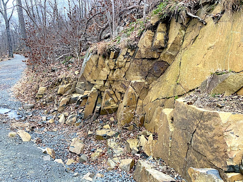
The sharp angles in this rock outcropping indicate its volcanic origins - its basalt
That's the sleeping giant's head ahead -- you hike through a ravine (more or less the giant's neck!). Hard to get a true feel from the photos but the cliff is massive!

The Tower

Built in 1936 by the WPA, you can ascend a series of dark interior ramps to get to the top.
You can imagine on a beautiful sunny day - the view would be awesome!


There was a picnic table in the fireplace room where I had an apple before descending back down the mountain.

The Descent

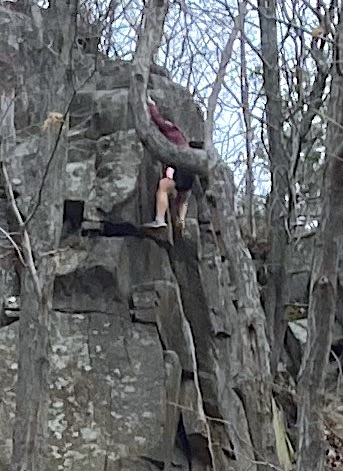
Careful observation - Yep that's someone climbing--Yikes!
The park is riddled with trails - next time (on a nicer day) I will return and hike the White or the Blue Trail - it looks like fun (and a bit of a challenge).
There was a short stairway shortcut I took on my way out.
I as drove out - I took this photo of the giant's head

Further Info

Sleeping Giant (Wikipedia)