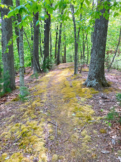
The Ridge Trail - looking good!
Wednesday, May 18, 2022
Friday, May 13, 2022
Crow Hill ATV Trails - Portland, CT
After my ride in the woods east of Keeney Street - I ventured down to Portland to explore riding the abandoned RR trail and ATV trails I saw a couple of weeks ago on foot.
Bummer but going east from Williams Street Extension wasn't possible - it's completely overgrown... The AllTrails map was misleading!
After a short unpleasant ride thru the overgrowth I turned around and rode on the trail section west of Williams Street Extension...
...Once I got near the end, I ventured uphill on a prominent old dirt road.It was uphill FOREVER and this old geezer had to walk some of it :-(Finally when I neared this house I veered to the left and kept slogging up and up and up...
 |
| There's a cement marker here - Probably a survey property border marker |
 |
| Maybe this old car was as tired of the uphill as I was! |
Another old relic from yesteryear...
The dinosaurs and mini-golf are have seen better days.....
Exploration and Discovery
In the morning I explored a bit of the Parcel north of Howe and discovered the remnants of an old road.
Here's a GPS of what I rode - I continued on down south of Howe as well (not on map).
Here''s an overlay of what I rode with the crazy ATVs trail I mapped last year. North of the dry streambed I discovered an old road...
It kinda hard to tell from this photo but this is where the trail dips thru the dry streambed.
The stretch I bushwhacked...Here's the old road...
This is the main artery - the climb back up to Howe starts here
Thoughts on this location
Wednesday, May 11, 2022
The missing link...
I took a short hike in the evening on the Waterline Trail east of Keeney. It was a productive hike as I found the trail link over the stream bed.
 |
| I went right at the intersection South Branch |
 |
| There was another potential spot for a trail crossing here... Marked "Y" on map |
Where that defined trail turns to the right is where the missing link exists...
The descent takes you down to the stream crossing...
 |
| The stream crossing - not too messy! |
Once on the south side of the stream, its a short messy climb to get to the former ATV trails...
I took this trail remnant up to where it intersected with the main trail |
| Yep - this is the main trail... |
Here's the crossing going back north - the water line trail is the flat section ahead...
Monday, May 9, 2022
East Of Keeney - Hike/GPS
Subscribe to:
Posts (Atom)


