Every time we drove by this trail entrance I was curious about it so today I hiked it.

Although initially I thought it might be an old abandoned carriage road, I believe its merely a water line when I saw the manholes:


At this juncture the main water line went straight up the hill and I turned left onto a very obscured single track...


...that soon paralleled a ravine. It was very scenic.


I decided to turn around here because basically the trail disappeared but the late afternoon sun made everything look very enticing...

...and I even spotted a small waterfall on the way back!


The late afternoon sun really was nice!

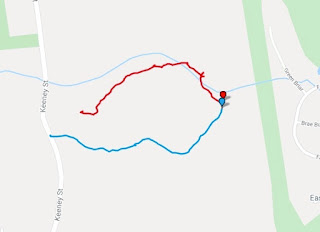
GPS Map of the hike
Blue route is the wide water line. The red route is the obscure single track. Please note the red route is a bit off - I didn't cross the stream but otherwise it was cool to see the stream (Salmon Brook) and the topo relief of the area...

No comments:
Post a Comment